Announcement

Collapse
No announcement yet.

Be ready for severe weather this fall

Collapse
X
 
  • Filter
  • Time
  • Show
Clear All
new posts

  • Be ready for severe weather this fall

    After being in hibernation the past few years thanks to the drought, weather officials say, Second Season could awaken around Kansas this fall.

    Second Season is the name given to the small spike in tornadoes that happens most autumns somewhere in the U.S.

    “The indications are the latter half of September and October will be wetter than average” in Kansas, said Mike Smith, senior vice president for AccuWeather. “That’s where we get our severe weather.”
    Read more here: http://www.kansas.com/2013/09/01/297...#storylink=cpy

  • #2
    Anything is possible if you are able to get the right setup, but in this story they point out the likely pattern for this fall won't be conducive to Severe Weather. The bigger threat is flooding - "Go Around, Don't Drown".

    Forecast models suggest a “northwest flow” pattern may set up over the Great Plains later this fall again, forecasters say. While that opens the door for persistent showers and thunderstorms, Carbin said, it is not conducive to the formation of tornadoes.
    Climatology wise the peak "fall" tornado threat for the SC Kansas is now and will be declining from here on out.

    torn1.jpgtorn2.jpgtorn3.jpg


    Comment


    • #3
      Ehh there's always a second season system about once a year.
      Last edited by wsushox1; September 2, 2013, 03:11 PM.
      The mountains are calling, and I must go.

      Comment


      • #4
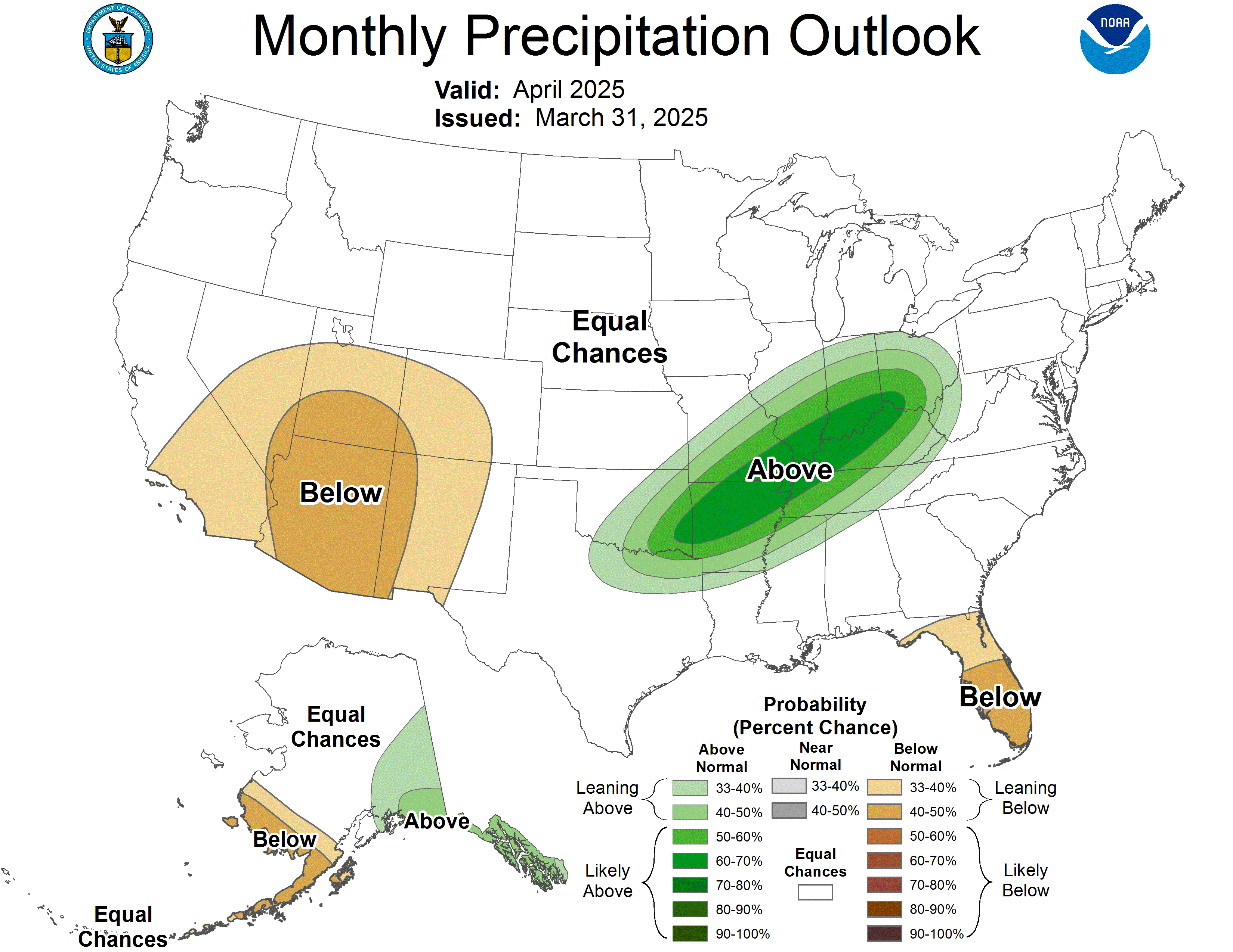
        Another thing, here is the one month precipitation outlook from the CPC (which has a mediocre track record at best).


        As you can see the SW United states and the MW/OV has the highest predicted chances of above normal rainfall. This is because of the pattern since about the middle of August of a stout ridge over the Central CONUS that is helping to draw moisture into the SW/Great Basin area which has contributed to a much-needed rainy monsoon season in the SW. In the OV the reason for above normal precip (predicted) is that subtle waves have been traversing over top of the High Pressure ridge and essentially causing rain. This is not a signal that is conducive to Severe WX in Kansas.

        However, as SB Shock has said with the right set-up anything - and any mode of severe wx - is possible. As stated, it apperas as if a NW Flow pattern might set-up which could lead to heavy rain along stalled frontal boundaries
        The mountains are calling, and I must go.

        Comment


        • #5
          Even if we miss out on tornadoes, we'll probably get a few hailstorm's

          Comment


          • #6
            Originally posted by BenWSU View Post
            Even if we miss out on tornadoes, we'll probably get a few hailstorm's
            If the patterns somehow change from what it is now, it could happen, but it doesn't seem likely at this point. Additionally climatology wise the probabilities for this window is declining rapidly and there is no sign of anything happening any time on the horizon.

            Last year in all of KS the breakdown for severe weather days was

            2 Days in early Sept
            1 Day in late Sept.
            1 Day in Oct
            1 Day in Nov.
            Last edited by SB Shock; September 2, 2013, 11:59 PM.

            Comment


            • #7
              Today is one of those 4 or 5 days we have in the fall where some strong storms are possible. No significant tornado threat, but there will be a chance for marginally severe hell. It is not an impressive setup, but it would be nice if we got some rain.

              Capture.JPG
              Last edited by SB Shock; September 15, 2013, 09:07 AM.

              Comment


              • #8
                Originally posted by SB Shock View Post
                but there will be a chance for marginally severe hell.
                Some of us have a bigger chance of hell than others. You know who you are!

                Comment


                • #9
                  I admit I am on the highway... but several Shockernetters have put me in the ditch in their hurry to get there.

                  Comment


                  • #10
                    Originally posted by SB Shock View Post
                    No significant tornado threat, but there will be a chance for marginally severe hell.
                    Will that include fire and brimstone?

                    Comment


                    • #11
                      Brimstone only, according to reports.

                      Comment


                      • #12
                        The end of the week is looking as if severe weather will be possible. All modes as well.
                        The mountains are calling, and I must go.

                        Comment


                        • #13
                          Originally posted by wsushox1 View Post
                          The end of the week is looking as if severe weather will be possible. All modes as well.
                          You think so? The last time I looked the timing looked a bit off. I'll take a look at it later.
                          Deuces Valley.
                          ... No really, deuces.
                          ________________
                          "Enjoy the ride."

                          - a smart man

                          Comment


                          • #14
                            Originally posted by ShockerFever View Post
                            You think so? The last time I looked the timing looked a bit off. I'll take a look at it later.
                            You're right, the timing was bad with the system. However, today's 12z and 18z GFS runs have slowed the system down to to where the main event in this area would be Friday instead of Thursday. Also, Friday (from todays runs) appears to be more dryline initiated convergance rather than cold front. This would help with keeping cells discrete, though the cold front quickly races to the south-east.

                            If it continues to slow down, ie the surface boundaries moving further west and a decent LLJ it could be one of the stronger "second season" events we've had in a while. Tonight's 0z GFS will give a clearer picture.
                            The mountains are calling, and I must go.

                            Comment


                            • #15
                              I can't say I have been paying much attention but from the little I have seen it looks like anything that might happen will be more in NE Kansas. Maybe some good snows in Nebraska/S. Dakakota.

                              Comment

                              Working...
                              X